Guadalupe Peak – Guadalupe Mountains National Park, Texas
This summer I am taking a group of teenagers Backpaking in the Arapaho National Forest outside of Denver Colorado. We plan to spend 3 nights in the backcountry and summit a 13,000 foot mountain. Many of these young people have never been backpacking, or camping and some have never even been hiking. I knew many of them had signed up without knowing what they were getting themselves into. So as a “warm-up” hike we headed out to Guadalupe Mountains National Park to summit Guadalupe Peak. Click here to read my previous Guadalupe Peak summit backpacking trip.
On the Summit of Guadalupe Peak
I use the word “warm-up” loosely. A day hike to the summit of Guadalupe peak climbs over 3000 feet in just over four miles. Many people who have climbed Guadalupe Peak say it is tougher than anything you might encounter in Colorado. I don’t know about that (my Colorado hiking experience is very limited). But I do know we will be in higher altitude in Colorado and have heavier packs. So I chose Guadalupe peak to confirm the teens that were up for the challenge and discourage the ones who are not. All without saying a word… I was going to let the mountain do the convincing.
Pine Springs Canyon near the base of Guadalupe Peak
So on the first day of National Parks Week, 16 teens and 6 adults started off climbing 8,751 foot (or 8749 foot depending on who you ask) Guadalupe Peak , the highest peak in Texas. With free admission into the park it started off as a crowded day. We arrived about 9:00 am and already one parking lot was full. We had to park in overflow parking. This extended our hike by a little but, what ‘s a half mile when you plan on hiking eight?
Virtual Hike up Guadalupe Peakthat I recorded with my Helmet cam
As we headed up the trail I could already hear some huffing and puffing from the young people behind me. The first mile of the Guadalupe peak trail is some of the steepest the entire hike. You gain a 1,000 feet in under 7/10 of a mile. Before we had gone ½ mile I already had one teen and one adult heading back for the parking lot.
The view along the first mile of Guadalupe Peak Trail
Posing on a precarious rock
Posing on a precarious rock
Looking back north on the Guadalupe Peak Trail
Looking East on the Guadalupe Peak Trail. You can see the contrast between the northern and southern facing slopes.
Looking north through the Guadalupe Campsite meadow at Hunter Peak.
The rest of us pressed on, slowly. Before we had reached 2 miles we stopped to eat lunch in the shade of the mountain. I knew most of this hike still lay before us…but I didn’t want to push anyone to hard. As we continued it became evident who was enjoying themselves and who was not. We stopped to take a group picture on the highest bridge in Texas. So far everyone was still with us, but some where considering turning around. We were now less than a mile from the summit and we encouraged everyone to push on just a little further to the top.
The Group on the Highest Bridge in Texas
On the last push toward the summit
Looking back at the Bridge
Looking down on the Guadalupe Peak backcountry campsites
view to the west down Guadalupe Canyon
As we rounded the corner to the summit we found tons of people up there. Luckily Guadalupe Peak has a large summit where we could all spread out. I headed to the west end of the summit where Guadalupe Peak drops abruptly to the desert floor. From there I could see the Salt Flats and Williams Ranch. On a clear day you can see Sierra Blanca, but not today. All the smoke from the Fort Davis Fires where making things hazy. We spent 30 to 45 minutes on the summit. By the time I had rejoined the rest of our group everyone else was gone. We had about 10 min with the summit all to ourselves.
Approaching the Summit
Some of the group pose for a picture just below the summit
Salt Flats to the East. The Guadalupe mountains used to be a limestone reef when this area was covered by ocean. The salt flats were formed when the ocean receded and water gathered in low lying areas. The water eventually evaporated leaving the salt.
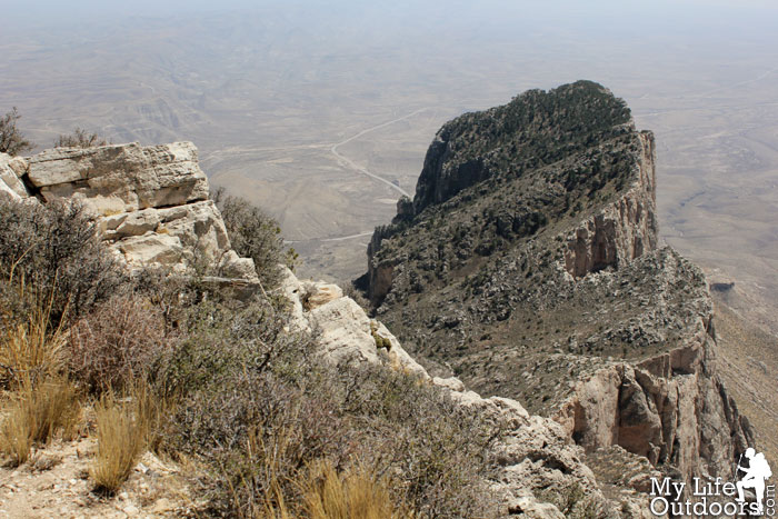
El Capitan viewed from Guadalupe Peak.
Cactus Flowers on the Summit
As we headed down I was impressed that no one else had turned back after our initial two. Everyone was tired with sore feet. Some vowed never to do anything like this ever again. But many others were excited for our upcoming trip to Colorado.
Heading back down
Guadalupe Peak Trail
The Hike: Starting Elevation: 5734 feet Ending Elevation: 8751 feet Elevation Gain: 3017 feet Trail Length: 4.2 miles (one way) Fee: Entrance fee is $5.00 per person for adults 16 years of age and older GPS file: GPX of Guadalupe peak Trail
Resources: I use both the Map and Guide book featured below when planning my many trips to the Guadalupe Mountains. I highly recommend them to anyone wishing to hike there. Purchase them through these links and help support MyLifeOutdoors.
this is an awesome post. looks like our time in Texas is about over, so i will never get to head down for this hike! it's hard to believe that place is in Texas, all i ever see is plains!! thanks so much for posting, the cactus flower was gorgeous!
I'm sorry to hear your leaving Texas. The Guadalupes are a site to see if you ever get back down this way.
ZSandmann,
It took us about 4 hours to get up and about 2 hours to get down. We spent 30-45 min on the summit. We are headed to 13,641 foot Bard Peak. We had some of the teens struggle with the elevation on Guad Peak, and that is the elevation we will be starting at in Colorado. Since this trip we have had 5 teens back out on the Colorado trip. I haven't tried to convince them one way or the other.
I'm sure the teens will have a very memorable trip to Colorado! And I think this kind of test walk is a very clever idea, so they can get a feeling what they are up to and back out if they feel so. Maybe those who now cancel will do something similar later on, or then not. It's up to them.
Your trip report is excellent. I very much enjoyed your helmet cam. I wonder what kind you had because it had such good clarity and no vibration. Very nice.
I've never done Bard so I can't offer any advice there. Elevation can be a pain (literally) but we didn't have any problems other than very minor headaches. Sorry to hear five dropped out but that may not be a bad thing, you want everyone to enjoy themselves and a few that aren't can ruin it for everyone plus then you have to worry about everyone's health and such.
Sometimes I feel like the best church I enjoy most are the mountains and I bet these young people you took to the Peak may feel like that, too. Thanks for taking them!
Norman Rick
April 3, 2012
We are gearing up for another mammoth hike up Guadalupe Peak again this year. Our group met yours last year on the same hike that day and your blog with video and photos is a great way to introduce the hike to newbies for this year. I hope this report never goes away because it is a great help to those future hikers not sure of what to expect. Thanks for posting it and keeping it available for all to see and use.
I'm glad we ran into your group that day and I'm glad you find the post and video useful. I hope your group has a great time on Guad Peak this year. Thank you for introducing so many to the great outdoors.


ZSandmann
Wow that is a dedicated bunch! Just curious with a group that large what your time up and back down was?
What is your intended target in Colorado? I've done a couple of 13ers out there and none seemed nearly as hard as Guadalupe Peak.
Hiker Trash
this is an awesome post. looks like our time in Texas is about over, so i will never get to head down for this hike! it's hard to believe that place is in Texas, all i ever see is plains!! thanks so much for posting, the cactus flower was gorgeous!
Steven
Hiker Trash,
I'm sorry to hear your leaving Texas. The Guadalupes are a site to see if you ever get back down this way.
ZSandmann,
It took us about 4 hours to get up and about 2 hours to get down. We spent 30-45 min on the summit. We are headed to 13,641 foot Bard Peak. We had some of the teens struggle with the elevation on Guad Peak, and that is the elevation we will be starting at in Colorado. Since this trip we have had 5 teens back out on the Colorado trip. I haven't tried to convince them one way or the other.
-maria-
I'm sure the teens will have a very memorable trip to Colorado! And I think this kind of test walk is a very clever idea, so they can get a feeling what they are up to and back out if they feel so. Maybe those who now cancel will do something similar later on, or then not. It's up to them.
Very nice you are organizing this kind of trips!
gumo
Your trip report is excellent. I very much enjoyed your helmet cam. I wonder what kind you had because it had such good clarity and no vibration. Very nice.
ZSandmann
I've never done Bard so I can't offer any advice there. Elevation can be a pain (literally) but we didn't have any problems other than very minor headaches. Sorry to hear five dropped out but that may not be a bad thing, you want everyone to enjoy themselves and a few that aren't can ruin it for everyone plus then you have to worry about everyone's health and such.
The Smoky Mountain Hiker
Great report! Makes me wish I could hike this again….
Steven
GUMO,
Thank you, I used a GoPro HD Hero Cam. The lack of vibration is due to the extreme wide angle lens. 170 degree field of view.
Everyone,
Thank You to everyone for your comments. They are always greatly appreciated.
Anonymous
That is awesome of you to lead these hikes/backpacks for these kids! I'm sure they will all thank you later for giving them this kind of experience.
gumo
Sometimes I feel like the best church I enjoy most are the mountains and I bet these young people you took to the Peak may feel like that, too. Thanks for taking them!
Norman Rick
We are gearing up for another mammoth hike up Guadalupe Peak again this year. Our group met yours last year on the same hike that day and your blog with video and photos is a great way to introduce the hike to newbies for this year. I hope this report never goes away because it is a great help to those future hikers not sure of what to expect. Thanks for posting it and keeping it available for all to see and use.
Steven Smith
Norman,
I'm glad we ran into your group that day and I'm glad you find the post and video useful. I hope your group has a great time on Guad Peak this year. Thank you for introducing so many to the great outdoors.